Wild, Wonderful and Well-Documented
Scanning West Virginia Land
Records with the Zeutschel 12000

Wild, wonderful West Virginia. For me, these words ring very true. Harpers Ferry has become one of my favorite places to visit in recent years for its natural beauty, challenging – yet fun – hiking trails and compelling history. Harpers Ferry resides in Jefferson County, which is also known for its compelling history, beauty and rising popularity.
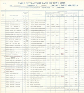
The Jefferson County West Virginia’s Assessor’s Office is currently digitizing land records to help the county keep track of changes in ownership and estimate land value. Their collection of 30,000+ bound and loose materials are being scanned by Victoria (Tori) Myers, Mapping Specialist for the Assessor’s Office, to create easily accessible digital records. These records will be made available online for the citizens of Jefferson County to view, share and use in personal and public research.
Jefferson County, WV
The Jefferson County Historic Landmarks Commission (JCHLC) gives a great overview of the county’s history but for the sake of time (and story), here is a brief summary.
In 1801, the county of Jefferson was created from parts of Berkeley County, Virginia and named after the third president of the United States and Virginia native, Thomas Jefferson. During the Civil War, Jefferson County’s proximity to Washington, DC and the Baltimore and Ohio Railroad (which ran through its borders) made it the scene of many bloody battles. Union and Confederate lines moved back and forth along the Shenandoah Valley; several towns within the county switched hands between the two sides throughout the war.
Between 1863-1866, the state of West Virginia was established from both Berkeley and Jefferson counties. The many towns within their borders – including Shepherdstown, Charles Town, Harpers Ferry and many others – were confirmed in the new state.
How the Land Changes Hands
Jefferson County has continued to see countless changes over the 221 years since its establishment. In 2022, it is attracting the attention of land developers due to low land prices and flexible city and county zoning regulations.
These changes have been, and continue to be, chronicled in the records of the Jefferson County Clerk* and the Jefferson County Assessor’s Office. Working closely with one another, the two offices preserve records which track ownership, property lines and any changes to the land. The records are also used to assess market value on personal and business properties.
“Our records date back to 1801, when the county split off from Berkeley,” Myers begins. “The Assessor keeps track of all maps, change cards (which note changes made to the maps themselves), old land books, deeds and all backup information need for our job of assessing property in the county.”
Digitizing Land Records
The Assessor’s Office holds hundreds of years of land books and the accuracy of the information on the records is critical to properly assessing properties. As land in West Virginia has become more popular with developers and private buyers over the years, so has the need for quickly accessible digitized land documents.
When Myers began working at the Office in 2005, scanning was done on an as-needed basis using a simple large format scanner. Expanding and accelerating the county’s digitization plan was motivated by two factors:
- Disaster prevention: After witnessing the effects of the Morgan County, WV Courthouse fire in 2006 – which destroyed one third of the county’s birth certificates, deeds, county maps and other records – the Jefferson Assessor’s Office decided to scan all their records to prevent a similar loss in their county.
- Efficiency: Before large-scale digitization, Myers made multiple daily trips to the records vault to pull documents. Through digitization and the subsequent digital access to the same physical records the Assessor’s team could expedite internal workflows and improve public online information access. The added bonus is preservation – digital records allow the physical materials to remain safe in storage while multiple digital copies can be created for assurance.
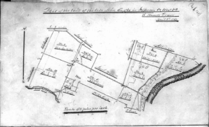
Using their existing large format scanner, Jefferson County took on its first large-scale digitization project of capturing map cards. These track landowners and identify which deed books hold their corresponding documentation. After the completion of the initial project, new scanning projects were selected based on media fragility and research popularity. Throughout their digitization journey, the county has acquired additional hardware as needed and, as a result, owns various scanner types and models.
Breezing through Pages with the Zeutschel 12000 Advanced
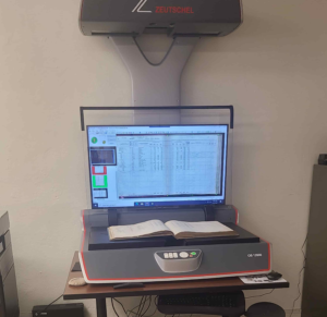
By 2019, the county’s bound land and deed books were next in line for digitization but they did not own an overhead scanner that could safely scan the bound material without damaging the book spines/binding. The county decided to look for a scanner that could fit this need. “We had permanently bound books that were unable to be scanned non-destructively. The County Clerk, in conjunction with the Assessor, made the decision to purchase a scanner,” says Myers.
After receiving bids and applying for grants, the Clerk and Assessor chose to purchase the Zeutschel 12000 A1 book scanner for its image quality, capture speed and affordability. The 12000 A1 captures in 600 ppi and has fast scan speeds and workflow automations, ensuring an expediated scan process that produces accurate digital reproductions of the original records.
Country Records, Take Me Home
At an impressive scan rate of over 1,100 pages per day, Myers has already completed the first major project of scanning land books in a short amount of time.
“I love the scanner. Normally, I can get two 550-page or so books scanned per day,” Myers states. “Since we got [the 12000], I have finished all 152 land books and all the deed indexes. I am now working on the bound deed records and have scanned over 72 books [out of 920 physical books in the collection].”
As they are completed, the digitized land books are published on the Assessor’s website for public reference. The deed and deed indexes will be added online at the discretion of the County Clerk.
“As far as public reaction, [our residents] certainly enjoy having access to the information,” remarks Myers. Internally, the digital documents have provided the Assessor’s team with peace of mind that their information is safe from disaster and helps hasten their processes in terms of proving land assessments.
The Assessor and County Clerk both have future collections planned for the scanner and see no decline in the need for online records anytime soon. I applaud the Assessor’s Office, County Clerk, Myers and others that continue to ensure West Virginia lands stay wild, wonderful and well-documented. We will continue to watch for the impressive online collections coming from their Zeutschel scanner!
Bring Your Government Records to the Digital Realm
For more information on how The Crowley Company’s scanners and services can help preserve government collections for online access, visit www.thecrowleycompany.com or call (240) 215-0224.
*The County Clerk and the County Assessor are both elected officials which sometimes work together in their records and documentation departments.
Update:
As of September 2023, Zeutschel no longer manufactures the OS 12002-Series. Its replacement, the OS C, offers the same ease of use, image quality, and flexible software options perfect for library, archival and research use.

Crowley’s former Communications Coordinator, Hannah Clawson, cultivated a profound passion for historic preservation and held a deep appreciation for the company’s clients and their invaluable contributions. You may still likely find her exploring local coffee shops, writing about her favorite bands, or enjoying a local rock show.