Seven Miles, 500 Years of Stories: Jekyll Island History Preserved through Map and Blueprint Scanning
![]() From native hunting land to illegal slave port to millionaires playground to family vacation destination, the coastal beaches and blooming land of Jekyll Island, Georgia have drastically transformed over the past 500 years.
From native hunting land to illegal slave port to millionaires playground to family vacation destination, the coastal beaches and blooming land of Jekyll Island, Georgia have drastically transformed over the past 500 years.
Through a collaboration between Jekyll Island Museum Archives, the Jekyll Island Authority and digitization partner, The Crowley Company, nearly 5000+ pages of oversized land maps and blueprints of Jekyll’s infrastructure and historic homes have been preserved and made digitally accessible. This week’s blog gives a glimpse of the Island’s history, the significance of the collection and its potential future impact.
Native Hunting Land to Illegal Slave Port (1500-1878)
The modern history of Jekyll Island can be split into five eras: pre-colonization (pre-1500); colonial (1500-1778); plantation (1792-1878); club (1879-1946); and state (1947-present).
In its pre-colonization era, Guale and Muscogee (Creek) Nations people lived and traveled upon the seven-mile-long island to hunt and fish. French and Spanish explorers competed for control of the land throughout the 1600’s but were all eventually overpowered by the English in 1733 when General James Oglethorpe established a colony on the land.[1] Oglethorpe named the islhttps://www.mcn-nsn.gov/culturehistory/and in honor of Sir Joseph Jekyll, his friend who had rallied for funding when the colony was at the end of their financial rope.[2]
In 1772, the elite DuBignon family arrived on Jekyll Island seeking refuge from the French Revolution. They purchased the island from the English piece-by-piece and developed a plantation system. Fifty years after Congress banned the slave trade in 1808, a ship called “The Wanderer” illegally smuggled 400 captives onto Jekyll Island, making it the last ship to bring to bring enslaved Africans to America.
Millionaire Playground: The Jekyll Island Club Era

In the late 1800s, John Eugene DuBignon and his brother-in-law, Newton Finney, collaborated to turn Jekyll Island into an exclusive private hunting club for some of the nation’s wealthiest individuals.[3] To join, prospects were required to buy two shares of the club of which there were 50 shares total. The club welcomed 25 lucky (and big-pocketed) members every season for hunting, fishing, golf and other sporting and relaxation activities.
By the early 1900s, the Jekyll Island Club roster included the prestigious families of Rockefeller, Vanderbilt, Pulitzer, Morgan and other titans of industry. Many members took the opportunity to build mansion-sized “cottages” on the island as their vacation homes, the majority of which are still standing today.
With that much wealth and influence on the island, it is not surprising that it was the seat of several historic events. A secret meeting of financial leaders, headed by Senator Nelson Aldrich of Rhode Island, was held on Jekyll Island in 1910. It resulted in the creation of the Federal Reserve and the start of our modern banking system. In 1915, the first US transcontinental telephone call between Alexander Graham Bell in New York and Thomas Watson in San Francisco also included lines connecting AT&T President Theodore Newton Vail on Jekyll Island, GA, President Woodrow Wilson in Washington, DC and Henry Higginson in Boston, MA.4

The Club enjoyed years of success and some tragedy. Despite the collective wealth of its members, the Club still suffered the Great Depression. In April 1942, four months after the attacks on Pearl Harbor, a German U-boat torpedoed and sunk two U.S. merchant ships – the SS Oklahoma and SS Esso Baton Rouge – off the coast of nearby St. Simons Island. The already weakened Club was evacuated and many of its employees joined the armed forces or at-home war efforts to support America’s position in World War II. Without visitors or hired hands, the Club officially closed its doors.
Once the war ended, Georgia State purchased the land and developed it into a State Park. The Jekyll Island Authority was established to manage and support the functions of the island. The Authority remains the governing party over the wellbeing of the island including stewardship over its archives.
5,000+ Pages and Countless Stories
In 2016, the Jekyll Island Authority teamed with the Jekyll Island Museum, Mosaic, on the map and blueprint scanning project which is shared between their two institutions.
“The blueprint and map collections were selected due to the varied use by both staff, island residents and researchers,” explains Rose Marie Kimbell, archivist & records manager consultant for the Jekyll Island Authority. She continues, “Some of these blueprints are old and battered, others are rare and integral to the infrastructure of the island. Digitizing these provides easier access, while protecting the original documents for future generations.”
The 5,000+ pages of blueprints and maps is a part of the Museum’s larger holdings which consist of 96 recognized collections holding 30,000+ items including photos, slides, books, papers, letters, postcards, records, manuscripts, scrapbooks, maps and blueprints which cover the colonial era through current state era of the Jekyll’s history.

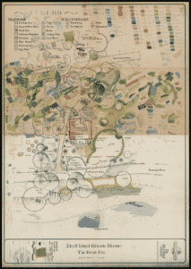
The maps and blueprints hold information vital to the historic homes and structures on the island as well as practical details used as reference materials for Jekyll’s infrastructure, such as sewage and water systems, roads, and natural resource. Various documents chronical restoration plans, surveys and research and more on famous Club members lavish cottages, including Villa Ospo, Villa Marianna, Cherokee, Goodyear, Hollybourne, DuBignon and Crane Cottages. Newer documents such as those for the Georgia Sea Turtle Center show the island’s efforts to push towards a new era of revitalization.
Map and Blueprint Scanning

Jekyll discovered Crowley online. After collaborating on the project details and reviewing sample scans from a pilot sample, Crowley was chosen as their digitization partner for the project. “The materials in this collection are large and require special equipment to digitize them,” Kimbell explains. “We chose The Crowley Company based on their capabilities for digitizing items of this size the quality of work they produce and overall cost.”
The map collection was curated from multiple storage locations around the island and moved to two primary locations to be inventoried, accessioned and sorted into sub-collections: Historic District blueprints; Jekyll Island Infrastructure blueprints; and Residential blueprints. To ensure safe delivery of the materials, Jekyll Island Authority’s carpentry department made crates for the materials to be carefully transported from Georgia to Crowley’s Frederick, Maryland scanning bureau. Once received, the non-fragile maps were scanned on a large-rotary map scanner while other delicate maps were scanned on Zeutschel large-format overhead scanners.
“We appreciate how patient the Crowley team has been, knowing that this project has taken several years to get to this point, and being a good partner every step of the way. They have stayed in constant communication and have not hesitated to ask questions when necessary,” remarked Kimbell. Researchers will be able to view certain blueprints online without restriction, while others with more sensitive content will be restricted for safety reasons. Eventually, the unrestricted maps and blueprints will be available on the Jekyll Island Museum Archive website.
“These images will not only help researchers learn more about the history of the island, they will have a practical use by our essential teams, such as the fire and water departments, to understand the critical infrastructures of the land and implement updates as needed to ensure the viability of our community groundwork,” Kimbell impresses.
Future Era
While the project was not the archive’s first scanning endeavor, it is the first step on the way to a larger digitization plan to provide easier access for researchers in Georgia and beyond. We hope that the digital collection ushers in a new era of prosperity and preservation for Jekyll Island.
OVERSIZED MAP AND BLUEPRINT SCANNING SERVICES
Crowley’s knowledgeable imaging experts and specialized hardware can digitize oversized materials of all kinds on budget and on time. Click here for more information on scanning hardware or to speak with a member of our team.
 Hannah Clawson, Crowley's former Communications Coordinator, cultivated a profound passion for historic preservation and held a deep appreciation for the company's clients and their invaluable contributions. You may still likely find her exploring local coffee shops, writing about her favorite bands, or enjoying a local rock show.
[1] https://www.lonelyplanet.com/articles/jekyll-island-history-beach-travel
[2] https://gastateparks.org/jekyll-island
[3] https://www.jekyllisland.com/history/island-history/